 Become a TechRadar Insider


Google Kite images come to Google Earth
Because Google Cars are so last year
Sign up for breaking news, reviews, opinion, top tech deals, and more.
You are now subscribed
Your newsletter sign-up was successful
Join the club
Get full access to premium articles, exclusive features and a growing list of member rewards.
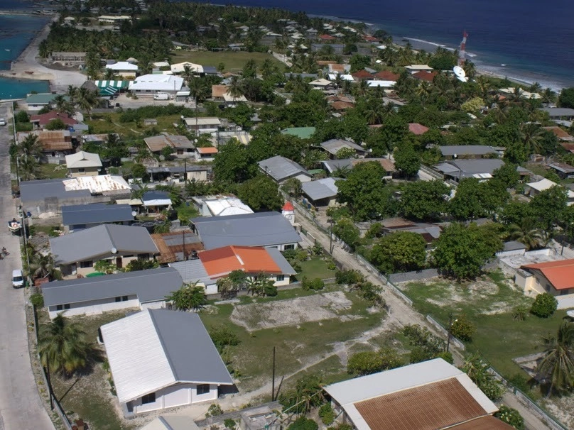
Google has started to add photographs taken from a kite to Google Earth, with the images coming from one of its own bloggers.
The images are from Google Earth blogger Frank Taylor who is on a five-year trip around the world by boat.
"I'm taking photos of the Earth in some places along the way just like what you see in Google Earth," said Taylor on the Google Earth blog.
"Only, some of the photos are even better than what you normally see because we are flying a camera only a few hundred feet above the ground with a kite."
Kite capture
As the photos were done by kite, there were a few things which had to be considered, like electricity pylons.
But Taylor does explain how he managed to get round the problem and at the same time interact with French Polynesian villagers of Manihi – the place he was taking images of.
Sign up for breaking news, reviews, opinion, top tech deals, and more.
"My goal was to capture parts of the village near the pass into the lagoon," said Taylor.
"We had time to walk down the main street on the north side. There were electric poles and wire and trees, so we couldn't quite capture the entire street.
"It was a really unique experience because the local kids and some of the adults all came out to find out what we were doing. We asked the kids to help us when we had to bring down the kite."
To view the kite-taken photographs go to Google Maps (search for Manihi Atoll, French Polynesia) or check out Taylor's Picasa picture page.

Marc Chacksfield is the Editor In Chief, Shortlist.com at DC Thomson. He started out life as a movie writer for numerous (now defunct) magazines and soon found himself online - editing a gaggle of gadget sites, including TechRadar, Digital Camera World and Tom's Guide UK. At Shortlist you'll find him mostly writing about movies and tech, so no change there then.