The best travel and weather apps for iPhone
Why you can trust TechRadar We spend hours testing every product or service we review, so you can be sure you're buying the best. Find out more about how we test.
Our favorite iPhone apps for planning a holiday, currency conversion, weather forecasts and mapping.

Currenzy
- $4.99/£4.49/AU$7.99
Currenzy isn’t your typical currency converter. Sure, it’s got the basics down: a calculator interface; a means to check out how a currency has performed against another; widgets; a way to define favorites. But the app goes much further than its contemporaries.
If you regularly perform certain actions, they can be stashed as big, tappable buttons, thereby speeding things up immeasurably. The app also has support for custom exchange rates and fees. Additionally, it works inside Safari, letting you convert prices on web pages from the currency that’s displayed to the one you need.
Along with all those things, Currenzy looks great too, making it the king of currency converters – and at a reasonable price for an app of such high quality.

CARROT Weather
- Free + IAP
CARROT Weather provides forecasts laced with snark from the CARROT AI, which has all the grace of a deranged HAL 9000. Rainfall predictions arrive with a message that it “sucks to be you”. Sunny days? “I brought out the sun so I can blind you with it.” Nice.
But CARROT Weather is more than a gimmick. It has best-in-class visual design and a powerful customization system. You get a wide range of panels and components to adjust and arrange to your liking. And when using the app, a long-press almost anywhere provides access to further data or useful settings.
All this – along with superb widgets and Apple Watch features – comes at a price: an annual subscription of $19.99/£19.49/AU$32.99. But if you care about the weather and want the best weather app around, this one’s worth the outlay.

Weather on the Way
- Free or $0.99/£0.99/AU$1.49 monthly
Weather on the Way is a weather app for road trips. Define start and end points and your route is displayed on a map. However, unlike in Apple Maps, weather symbols appear at periodic intervals, with temperature and conditions at each location alongside the estimated time you’ll drive through.
Everything’s usable and clear, weather alerts are integrated to warn you about potential problems, and there’s a linear timeline displayed when you press a massive button. This adds further details, including visibility and UV. Neatly, this timeline can be shared as an image.
The app gives you three journeys with full functionality for free. Subsequent journey information becomes more limited if you don’t pay, and you get stuck with a single route for each search. However, the low monthly IAP cost means you can always pay for this one when you need it, and unsubscribe when you don’t.
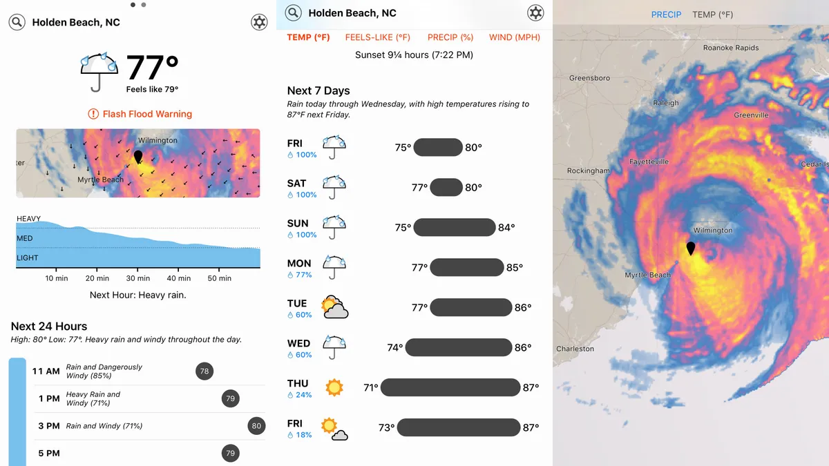
Dark Sky Weather
- US$3.99/£3.99
Dark Sky Weather started out primarily as a rainfall tracker, with luminous clouds billowing over a dark background map. Now, the app is much more conventional – but arguably massively more useful.
The main forecast page shows current conditions and a local map. Usefully, little arrows denote the direction a storm’s heading, so you can always spot that at a glance, rather than having to check the full animated rainfall view. Below that you get rainfall predictions for the hour, the daily forecast, and a weekly outlook. It’s all very sleek, efficient and usable.
The app’s accuracy may vary by location, but during testing in various countries we’ve found its rainfall predictions to be spot-on. It’s also a nicely flexible app regarding warnings – several notifications are built in, and you can add your own based on a range of weather conditions.

V for Wikipedia
- $5.99/£5.99/AU$9.99
V for Wikipedia is a Wikipedia reader. That in itself might sound like an odd recommendation for a premium app, but bear with us.
Although V can be used to search Wikipedia in the normal way, it starts off in its Nearby tab, flagging articles of interest in your vicinity. This looks great, tabs snaking their way from map locations to large thumbnails. It’s practical, too, for finding out more about the local area, without resorting to review-oriented web services.
This sense of polish extends to the article views. Typography and layout are first class, and a slide-in contents list is only a tap away. So while you might narrow your eyes at the prospect of paying for a Wikipedia reader, Viki will have said eyes busily and regularly reading the world’s most dynamic encyclopedia.

WeatherPro
- $0.99/79p/AU$0.99
WeatherPro is a weather app designed for people who favor information density over aesthetics. That’s not to say WeatherPro looks bad – its white-on-blue stylings are perfectly nice. But where it excels is in providing fast access to a wealth of weather data.
For any selected location, a single screen shows the current conditions, a local radar, upcoming predictions and then a forecast for the coming week. The latter packs temperatures, sun hours, precipitation forecasts and wind speeds into a tiny space.
In pretty much all cases, tapping on something lets you delve into even more information, and additional taps provide layered mapping and radar services. Accessing some layers requires an IAP subscription, but just the bare-bones WeatherPro is a great buy if you want at-a-glance forecasts packed with detail.

Citymapper
- Free
Citymapper is a navigation aid for finding your way around big cities. It doesn’t cover the entire globe, but is instead focused on a handful of major destinations, such as New York, Chicago, Tokyo, London, Paris and Sydney. Locations are periodically added by way of user votes.
If you live in or visit a supported city, Citymapper is superb for helping you find your way around more efficiently. The app quickly finds where you are and offers options – in real-time – of how to reach your intended target.
And small details really help it stand out, such as you being able to track the location of a bus you’re waiting for, alerts that blare when your stop’s coming up, and even recommendations of the best carriage to get on – and the fastest station exit to use.
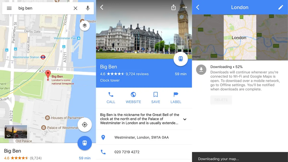
Google Maps
- Free
Google Maps is the best mapping app on iPhone.
It’s extremely good at locating places you want to visit, be that a distant town or a point of interest like a restaurant or store. When it comes to turn-by-turn driving directions, the voiceovers lack the nuance of Apple’s Maps, but the actual directions tend to be more helpful when it comes to dealing with incidents like congestion.
Google Maps is great for planning and non-car use, too. There are reviews and recommendations for places to go, public transport routing, and Street View – a navigable 3D street-level map for scoping out landmarks that proves handy when traveling somewhere or visiting a new place.
Importantly, you can also download chunks of map for offline use, turning Google Maps into a turn-by-turn navigator even when you lack a data connection.

Elk
- $3.99/£3.99/AU$5.99
We’ve lost count of how many currency converters exist on the App Store, but it’s vanishingly rare to see anyone try something properly different.
Elk bucks the trend, with a unique interface and approach that might not appeal to traders, but feels very much like currency conversion for the rest of us.
On firing up the app, you select your two currencies and it offers a list of current rate conversions. For USD to EUR, for example, you get a list of the rates for one through ten dollars. Swiping from the right increases these values by ten. To access rates between two values, tap an entry.
Smartly, you can also input a fixed rate, for example to track your spending on a holiday when you’ve already got your cash. Most of the features are behind a paywall, but a 14-day trial lets you try them for free.

Poison Maps
- $1.99/£1.99/AU$2.99
This one’s all about ‘points of interest’, hence the name – Poison Maps (‘POIs on maps’). Essentially, it’s a wealth of information from OpenStreetMap shoved into an app and twinned with an interface that makes it a cinch to drill down into categories.
So, mooching about London and fancy a bite to eat? Tap on the food and drink icon. Something quick? Tap Fast Food. Pizza? Sounds good.
Each tap filters the POIs and navigation buttons displayed, and arrows point at nearby locations when you’re zoomed in. Everything’s extremely responsive, and the maps and icons are clear and easy to read. Other nice bits include a full-screen mode, a search function, and public transport overlays.
The only snag is Poison Maps is a gargantuan install – well over 1GB. If that’s a bit rich, smaller regional alternatives by the same developer exist, each being a free download with a small IAP to unlock all categories.