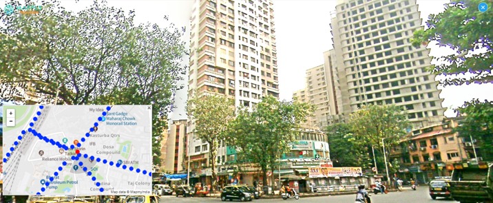
MapmyIndia launches made-in-India alternative to street view
It's named Mappls RealView

Google Maps, in India, enjoys a pretty dominant position. But its main rival here MapmyIndia, which as the name suggests is a indigenously developed product, has been spunky and coming with matching products.
On a day when Google Maps (re)launched its Street View service, MapmyIndia came out with its own Mappls RealView, which is a fully home-grown 360-degree panoramic street view. Mappls also offers 3D maps on the Metaverse.
Mappls RealView covers thousands of kilometres each in Greater Mumbai, Bengaluru, Delhi NCR, Goa, Pune, Hyderabad, Chennai, Jaipur, Ahmedabad, Gandhinagar, Chandigarh, Jodhpur, Patna, Nashik, Aurangabad, Ajmer and hundreds more towns and tens of thousands of kilometres of highways connecting these cities and towns, the company said.
Users can get interactive 360-degree panoramic views of tourist landmarks, beaches, residential colonies and apartment societies, office towers and the roads connecting these places. The service is available on multiple platforms: Desktop users may log in to www.mappls.com while mobile users can download the Mappls app on Android and iOS devices.
An Indian alternative to foreign offerings

Rohan Verma, CEO & Executive Director, MapmyIndia, said "we are excited to give to users in India, a fully indigenous alternative to foreign map apps, that is more advanced in its capabilities and is more valuable for users, while also being fully Indian."
The company said the Mappls RealView maps repository covers hundreds of thousands of kilometres already, including 40 crore+ geo-tagged 360-degree panoramas and videos and tens of thousands of 3D models and pan-India 3D data. MapmyIndia has already made live a part of its repository – covering nearly 100,000 kilometres across hundreds of cities and highways for free.
Enterprises and app developers can access and integrate more detailed RealView maps coverage as well as RealView technology-based APIs and solutions using data analytics, computer vision and AI. It can come in handy for use isn tourism, real estate, virtual reality, gaming, metaverse, intelligent road and traffic management, ADAS, autonomous vehicles, municipal governance, defence, law enforcement etc, the company said.
Sign up for breaking news, reviews, opinion, top tech deals, and more.
MapmyIndia has mapped more than 6.29 million kilometres of road in India, recording almost 18 million places to date.

Over three decades as a journalist covering current affairs, politics, sports and now technology. Former Editor of News Today, writer of humour columns across publications and a hardcore cricket and cinema enthusiast. He writes about technology trends and suggest movies and shows to watch on OTT platforms.