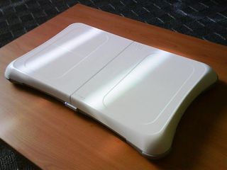
Google Street View stroll via Wii Balance Board
Ace programmer shows how to waste maximum time possible

Updated: You've gotta be pretty nerdy in the first place to tool around with Google Maps' Street View for more than 10 minutes (ok, ok, we know...), but hacking it together with your favourite gaming peripheral is a whole other level.
That's exactly what Ryo Katsuma, a Tokyo web developer, has done by hooking up his Wii Fit Balance Board with the Google Maps interface to provide a virtual walkthrough of any mapped neighbourhood.
Barefoot is best
The upshot is a slowly refreshing image of a street, upon which one can promenade by walking on the Balance Board to go forward and leaning on either foot to turn that way.
Speaking to TechRadar, Katsuma told us why he did it: "This was just my friend's idea. I thought it was possible and so started to develop it."
Amazingly, the intricate work didn't take long: "It took me four days to develop it - I developed the basic components last weekend and went on fine tuning it for two more days after that."
Do it yourself
Get daily insight, inspiration and deals in your inbox
Get the hottest deals available in your inbox plus news, reviews, opinion, analysis and more from the TechRadar team.
Katsuma's blog gives full details (in Japanese) of what he used and code for replicating the trick yourself. If you're interested, here's a flavour before you get started on that translation by yourself.
Katsuma used a Balance Board (duh), a Bluetooth receiver in his Mac, a Java signal-parsing module, a local web server, more Javascript and, of course, Firefox. Now go to it...
J Mark Lytle was an International Editor for TechRadar, based out of Tokyo, who now works as a Script Editor, Consultant at NHK, the Japan Broadcasting Corporation. Writer, multi-platform journalist, all-round editorial and PR consultant with many years' experience as a professional writer, their bylines include CNN, Snap Media and IDG.
Most Popular


