
 Become a TechRadar Insider


The big Google Maps update announced at Google I/O 2022 could be the most significant since the introduction of Street View in 2007. But its most exciting new feature, the drone-like 'Immersive View', won't just be a boon for travelers – as a photographer, I think it has huge potential for planning photo shoots, too.
Good photos often look like flashes of inspiration, but they're nearly always the result of careful planning. If you know what your composition, lighting and weather conditions are going to be like at a certain location ahead of time, you can save time otherwise spent waiting for a bolt of metaphoric lightning to strike. And Google Maps' Immersive View could well be a brilliant new tool for street photographers.
The new mode's hyper-real 3D mapping, which Google says has been built by fusing billions of aerial and street-level images together, is certainly useful enough on its own. Being able to pan around landmarks like Westminster Abbey, as Google's demonstration showed, could be a handy source of additional inspiration to use alongside existing tools like Google Maps' existing Globe View and Street View.
But what's particularly exciting about Immersive View, especially for street photographers, is that it combines 3D maps with simulations of the weather forecast at your chosen location. In Google's demo of the feature at London's Big Ben, you can see a dial at the bottom of the screen showing the date and time – swipe this and you'll see the weather, including shadows, the sun's position and the sky's conditions, rendered in impressive detail in the scene.
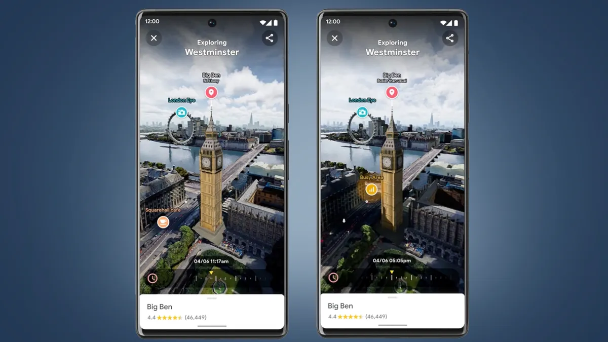
This is a highly impressive trick from a tech perspective, but it's also a really useful way for photographers to see when and where they should stand to get the best photo of a scene on a given day.
The early versions of Immersive View will no doubt contain some big limitations, most notably that it'll initially only be available in Los Angeles, London, New York, San Francisco and Tokyo when it lands "later this year". It also isn't clear exactly how precise or detailed Google Maps' renditions of the weather and sunlight will be.
But the promise is undoubtedly there and, because most of the processing is done by Google Cloud Immersive Stream, the new Immersive View can, according to Google, "run on any smartphone".
Digital camera bag

There are already lots of useful planning apps around for photographers. My current favorites are PhotoPills and The Photographer's Ephemeris (TPE). PhotoPills' AR mode helpfully shows you where in the sky the sun will be at a given time, while TPE 3D (the 3D version of its app) combines Google Earth-style 3D maps with detailed renditions of shadows around peaks.
But while the latter is ideal for landscape photographers and drone pilots, the sheer might of Google Maps' city data and cloud processing means Immersive View could well become my go-to for street and city photography. While I already know London's landmarks pretty well, it could come into its own when traveling to cities I know little about – which is why I'm keen to see how quickly it rolls out beyond those initial five cities.
It's easy to become blasé about iterative advances to Google Maps and Google Earth, but Immersive View does feel like it could be a step-change for the service. I still remember my office crowding around a computer to virtually visit each other's homes when Street View first landed. But the fusion of 3D mapping with by-the-minute weather and traffic data is so powerful it could almost be a form of time-travel – and that obviously has implications well beyond photography.
Another new Google Maps trick shown off at Google I/O 2022, the ability to 'fly' inside restaurants, suggests these next-gen Maps experiences could be fleshed out and expanded relatively quickly, too. Rather than relying on drone imagery, Google says the flying experience (see at 0:40 in the video above) is actually created using neural rendering from still images alone. This not only means it should be available to all kinds of businesses, regardless of budgets, but could also used to smooth the experience of flying around Maps' new 3D models.
For now, though, I'm looking forward to adding Immersive View to my photography toolkit, and using it to reduce the amount of time I spend aimlessly wandering, when it lands later this year.
