
 Become a TechRadar Insider


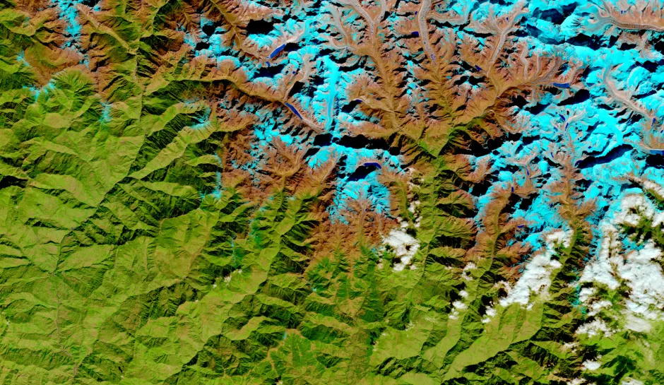
IBM has announced a collaboration with NASA to develop a foundation model trained on geo-spatial data provided by the agency to help advance earth science.
This model will be developed to be tunable and reusable, focusing on tackling climate change using new technologies and help advance weather forecasting, especially when it comes to extreme weather events.
IBM hopes to develop this foundation model in a fully open source environment and, upon completion, release it as a free to use tool for all communities to use.

New ways to learn
Machine learning is old news compared to foundation models. Previously, the data required to ‘teach’ a machine a certain task had to be labeled in a very laborious manner by researchers so that the machine knew, for example, that a zero is a zero and that a one is a one.
In very simple terms, foundation models can ‘self-supervise’ their learning by training its algorithm on a corpus (set of data) using masking or completion tasks - a very basic example of this could be removing a verb from a sentence, or removing the last word of a sentence - and then the algorithm completes the sentence and uses context from the corpus to see if it is right or wrong.
The data provided by NASA, such as the Harmonized Landsat and Sentinel-2 (HLS), includes over 40 years worth of weather data alongside readings from satellites and sensors. So just how far ahead, and how accurate, could we expect this model to be able to predict? Who better to ask than Juan Bernabe-Moreno, Director of IBM Research Europe for Ireland and the UK.
“If we think of the time scale, then you have narrowcasting, which is very, very immediate, almost, and you don't need much [data] to do a good job there. Then you have weather where you have days - the next seven days, next 10 days - where the difficulty starts, and then climate is a way longer process. We talk about months, even years.
“What's going to be the performance? That's something that's in the making. But the first results, they look very promising. We're in the process of defining the right architectures for the learning, and we have some encouraging results already.”
Extreme weather events are one of the main challenges facing this project, as artificial intelligence tends to stick closer to the predictable norms within the data, and extreme weather events such as El Niño tend to be outliers. Moreover, extreme weather events have been rarer in the past and are rapidly becoming more common, so using historical data that doesn’t reflect today's reality is another issue. According to Bernabe-Moreno, there are three perspectives.
“The idea is to use the technology to detect a pattern. This pattern is constituted by repetition. So the more extreme weather events we have, the easier it is to find the pattern. Then what we do is we try to analyze this window within when this particular weather event is happening.
“The third [thing] that we tried to do is to also understand and to put some constraints on top of the model. For example, can we use some physics to learn or to predict or to keep the boundaries of our prediction? Or do we need to train it in a particular way so that we don't remove the outliers in particular data points. So there's a lot of tasks that we have in our scope to try to tackle this strong weather event prediction.”

Endless applications
In a demonstration at the IBM Research Laboratory in Zurich, one of the use cases was for insurance, particularly around flooding detecting and identifying flood-risk areas for insurance. The foundation model has the potential to be used to predict the potential flooding impact in advance so that mitigation controls can be put in place.
“Also [you can] use this information to start taking some adaptation measures, and obviously that's something that insurance companies can acknowledge in terms of, well, in the event that it happens, I'm more comfortable. Given the coverage here, if I know that this measure has already been put in place.
“So that's one scenario, very particular, but just to show you the potential of this particular geospatial analytics.”
Even outside of insurance, the applications are seemingly endless. If your business or organization is threatened by any kind of weather, this foundation model can be used to identify those risks, simulate scenarios, and help plan for the worst case scenario.
“For example, for property development. So it's very important to understand how land use is evolving, how, again, we go to climate adaptation measures. Which climate adaptation measures are important? Which ones are in place?
“There are some very beautiful visual simulations on what the impact of the climate is if we didn't do anything in terms of adaptation, but we keep with the current, steady increase of temperature; the 1.5 scenario; the 2 scenario; the 3 scenario. You really get to see how these things happen. So, for property development it's very important.
“You have another way for agriculture. How is land use evolving and what are the consequences? And what's the right type of crop? And what's the right irrigation strategy? So there are many. That's the beauty about this foundational model.”

Climate collaborations
IBM recently announced its collaboration with the Science and Technologies Facilities Council (STFC) and Royal HaskoningDHV to identify how climate change and extreme weather could affect aviation operations in the future. It is hoped that the foundation model will be able to automate and scale climate risk assessment processes.
“Royal HaskoningDHV is a great engineering company, and they were very keen on engaging with us when they saw what we were doing with NASA, because they have great engineering skills, but they needed some help in terms of understanding, for example, the operations of an airport, right? Extreme weather events might affect, in the short term, the operation of an airport and how much does it cost?
“So they can quantify and they can take some measures, for example, understanding the flooding effect there. But also something very interesting that we are doing with them is trying to project the long term effect of climate change.
“So we are trying to understand the effects of climate change, using these product projections, on particular infrastructure. That's very new because you see that end to end. You see the effect of climate or weather, extreme weather events, and you see the monetary effect or the operational effect on something as essential as an airport.”
"A game changer"
One of the most exciting parts about this project is that the final product will be available totally open source and free to use for anyone. The main philosophy behind this decision is that research communities or communities local to a climate initiative should have the tools available to identify the impact of climate change and the steps being taken to mitigate its effects. This is what most excites Bernabe-Moreno.
“We are making these efforts quantifiable. So we could quantify the measures that the Kenyan government implemented with a number, in terms of, that's the above ground biomass this particular year, then there were some interventions in terms of putting in the fence, planting more trees here, and then we took another picture of the above ground biomass a few years later, and you can compute the delta and you can really compute also how much more carbon you can capture because you have a positive delta.
“It's a way for the community, for everyone, to have a tool where they can really track at community level things like, ‘We promised to invest so much in deforestation.’ Now you can really track that. And that's really encouraging because one of the problems we have with climate change is it is very abstract.
“It's very difficult to say ‘We planted so many trees.’ But where are they? What's the effect? How many did we lose, right? And now, actually we can measure, and that's for me a game changer.”
More from TechRadar Pro
