Google Maps adds UK rail info
Trainspotters rejoice

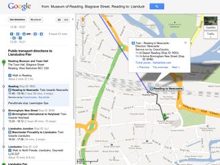
Rather than making you walk from London to Glasgow, Google Maps will now be able to tell you which train to get, where from and at what time thanks to new TheTrainLine integration.
The new partnership brings 2,500 mainland train stations to the Google Maps desktop and mobile apps, alongside 8,000 bus stops and over 250 tube stations.
You'll be able to plan journeys that combine walking directions, bus timetable information and train routes, as well as picking and choosing the transport options that suit you best.
Route planning
The update also gives you the option to click through to TheTrainLine.com to buy your tickets, although it doesn't seem to automatically take you to the journey you've just mapped, which is a little annoying.
But overseas visitors to the UK will be glad to hear that the new route-planning goodies can be used in all 50-plus languages currently supported by Google Maps. Good for the Olympics, yada-yada.
The new rail information has already rolled out to the desktop version of Google Maps (which you can also use through your phone's browser) but there's no word from either company on whether or not we'll see the handy route planning info make it to the dedicated mobile apps.
Unfortunately, while planned engineering works and bank holiday timetables will be incorporated, up to the minute delays and other unforeseen circumstances won't.
Get daily insight, inspiration and deals in your inbox
Get the hottest deals available in your inbox plus news, reviews, opinion, analysis and more from the TechRadar team.
Former UK News Editor for TechRadar, it was a perpetual challenge among the TechRadar staff to send Kate (Twitter, Google+) a link to something interesting on the internet that she hasn't already seen. As TechRadar's News Editor (UK), she was constantly on the hunt for top news and intriguing stories to feed your gadget lust. Kate now enjoys life as a renowned music critic – her words can be found in the i Paper, Guardian, GQ, Metro, Evening Standard and Time Out, and she's also the author of 'Amy Winehouse', a biography of the soul star.
