Google Maps gets sat nav-style POIs
Clickable links bring up reviews, contact details, Wiki info

The days of dedicated sat nav units look numbered, with the roll-out of yet another layer of navigational features for Google Maps.
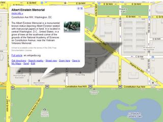
Google has now started to add points of interests to its Maps website, featuring tourist attractions, hotels, restaurants, bars and shops.
On the site, you simply click on the named landmark to pop up a window containing info and further links.
Wiki Washington
At the moment, only a few cities - including Washington DC - have been given the full treatment, with full contact details, photos, restaurant reviews, Wikipedia entries and links out, although most major cities have at least tourist attractions covered.
This does mean the Maps screen is getting increased cluttered with icons for public transport, StreetView, traffic information and now POIs, so it's a surprise that Google doesn't yet give you the option to filter out the new data. Also some images and text are a little flaky - displaying in portrait rather than landscape, for example.
The new POIs form an interesting contrast to Bing Maps, which brings social networking to navigation with filterable collections of POIs that you can either make yourself or browse for an entire neighbourhood.
Get daily insight, inspiration and deals in your inbox
Get the hottest deals available in your inbox plus news, reviews, opinion, analysis and more from the TechRadar team.
In related sat nav news, here's an interesting story from the Christian Science Monitor that quotes research suggesting that the more people have real-time traffic and navigational data, the longer journeys take for everyone.
Most Popular

