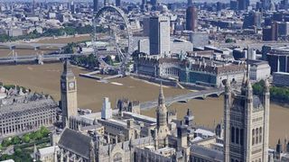
Fly around Big Ben with Google Maps' stunning 3D model of old London town
Second star to the right and straight on 'till morning...

Unable to get to the nation's capital for a spin on the London Eye this summer? Well Google might have the next best thing with its brand new 3D rendering of the city.
Accessible through Google Maps or Google Earth, users can fly across London like a digital Peter Pan zooming, panning, rotate and tilt around landmarks before stopping off at Harrods for tea and scones.
It's not just the tourist traps either. Google has followed the example set by that troublesome fire in 1666 and painstakingly included every building in London.
It's the fifth city in the UK to get the Google treatment, after the slightly less ginormous Leeds, Reading, Birmingham and Stoke-on-Trent.
Even the trees
Google has even incorporated the city's greenery by using photographs to automatically generate trees and what have you.
"Using 45-degree aerial imagery, we're able to recreate entire metropolitan areas in 3D," a Google spokesperson said
"This means every building, not just the famous landmarks, the terrain, and any surrounding landscape of trees are included to provide a much more accurate and realistic experience of the city. As you zoom into London on Google Maps or Google Earth, buildings and terrain will start to appear in 3D."
Get daily insight, inspiration and deals in your inbox
Get the hottest deals available in your inbox plus news, reviews, opinion, analysis and more from the TechRadar team.
Here, take a look at London as you've never seen it before.
Via Engadget
A technology journalist, writer and videographer of many magazines and websites including T3, Gadget Magazine and TechRadar.com. He specializes in applications for smartphones, tablets and handheld devices, with bylines also at The Guardian, WIRED, Trusted Reviews and Wareable. Chris is also the podcast host for The Liverpool Way. As well as tech and football, Chris is a pop-punk fan and enjoys the art of wrasslin'.

